

Best of India Tours
- Golden Triangle Tour- Best of India & Nepal
- Classical Rajasthan
India Cultural Tours
- Images of North India- Karnataka Heritage
- Rajasthan & Goa Tour
Discover India Tours
- Grand India Tour- North to South India
- Central to South India
Rajasthan Tours
- Classical Rajasthan Tour- Golden Triangle Tour
- Grand Mughal Tour
India Luxury Trains
- Palace on Wheels- The Golden Chariot
- India Deccan Odyssey
- The Indian Maharaja
- Royal Rajasthan on Wheels
Nepal Tours
- Glimpses of Nepal- Buddhist Pilgrimage
- Nepal River Rafting
- Destinations of Nepal
- Nepal General Info
India Wildlife Tours
- North India Wild Life- South India Wildlife
Tibet Tours
- Tibet Monastery Tours- Explore Tibet
- Destinations of Tibet
Spa & Yoga Tours
- Ananda in Himalayas- Yoga & Meditation
Adventure Tours
- Manali Safari Tour- Himalayan Trekking
- Horse Safari
Uttar Pradesh
Agra
![]() Allahabad
Allahabad
![]() Auli
Auli
![]() Badrinath
Badrinath
![]() Corbett
Corbett
![]() Kushinagar
Kushinagar
![]() Lucknow
Lucknow
![]() Nainital
Nainital
![]() Varanasi
Varanasi
In Uttar Pradesh, Lucknow was associated with the princely court of Oudh and then with the British, both traditions lingering on in the city whose finest monument is the Bara Imambada. Further east, Varanasi is the oldest city in India. An important centre of Hindu pilgrimage, it is believed that those who die in Varanasi will be released from the cycle of rebirth. Pious Hindus still come to Varanasi to spend their last days, living in Spartan communes run by a multitude of religious trusts. The focus of interest to a visitor is the sacred River Ganga. At the series of steps leading down to it, people come to wash away their sins by bathing in the river, the dead are cremated and holy men meditate. In the narrow by lanes of the city are crowded bazaars selling brassware and silk brocades.
Agra
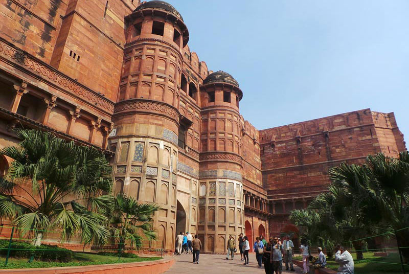
Agra is famous as being home to one of the seven wonders of the world-the Taj Mahal. A pleasant town with comparatively slow pace, Agra is known for its superb inlay work on marble and soapstone by craftsmen who are descendant of those who worked under the Mughals. The city is also famous for its carpets, gold thread embroidery and leather shoes. Agra, and the nearby city of Fatehpur Sikri, is conveniently close to Delhi to warrant an all day excursion by coach or taxi although there are several hotels of every standard of comfort.
Besides the Taj Mahal are Agra Fort, Sikandra, Ram Bagh and Itmad-Ud-Daula. 35 kms away are the imperial ruins of the Mughal city, Fatehpur Sikri. Agra is an old city and it is said that its name was derived from Agrabanad, a forest that finds mention in the epic Mahabharata.
 Climate:(deg C)-Summer- Max.45, Min.21.9; Winter- Max.31.7, Min.4.2.
 Rainfall:66 cms (June to September)
 Best Season: October to March
 Fatehpur Sikri – 35kms
 By Air:Agra is well connected with Delhi, Khajuraho and Varanasi.
 By Rail:Well connected with Bangalore, Bhubaneswar, Bombay, Calcutta, Delhi, Madras and other major cities.
 By Road:Agra is connected to Delhi- 204 kms, Jaipur- 237 kms, Khajuraho- 395 kms, Mathura- 54 kms, Gwalior- 110 kms, Lucknow- 257 kms, Bharatpur- 54 kms.
Lucknow
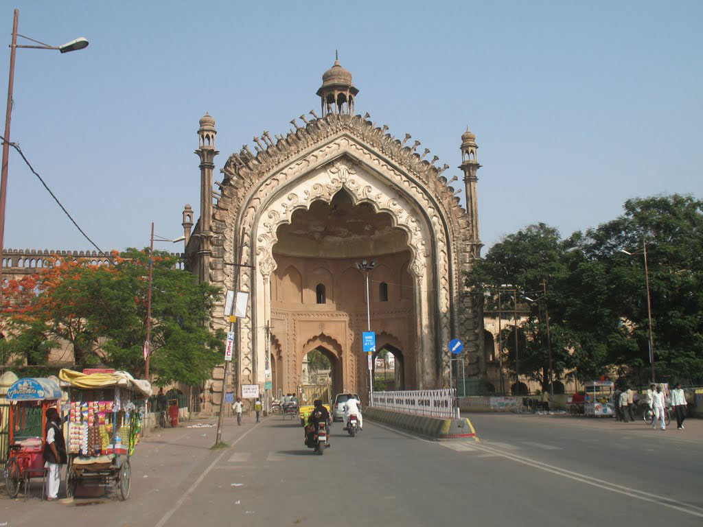
Lucknow is a city synonymous with the Nawabi Culture. The imperialistic splendor and magnificence of the Nawabi Era has been glorified and eulogized down the ages by writers, poets and historians alike. Lucknow is the capital of Uttar Pradesh, one of the biggest states in India and is situated on the banks of the river Gomati, tributary of the Ganga. It is famous for its Gardens, Parks and unique archaeological monuments. Lucknow is associated with its legendary hospitality, leisurely moods of life, fabled edifices steeped in history, world-renowned cuisine and exquisite Sham-e-Avadh.
 Altitude: 123 meters (403 ft. above sea level)
Climate:(deg C) Summer- Max 36.6, Min 25; Winter- Max 21.1, Min 11.1.
Rainfall:44 cms (June-Sept)
Best Season: October to March.
By Air:Lucknow is well connected to Calcutta, Patna, Delhi, Bombay.
By Rail:Well connected with all major towns.
By Road:Agra- 314 kms, Allahabad- 225 kms, Calcutta- 985 kms, Corbett National Park- 280 kms, Delhi- 514 kms, Kanpur- 79 kms, Varanasi- 314 kms.
Ayodhya
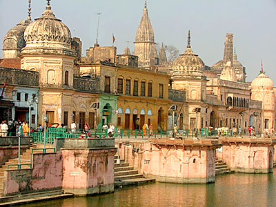
Ayodhya is prominently a city of temples. At Ayodhya several religions have grown and prospered simultaneously and also at different periods of time in the past. Remnants of Hinduism, Buddhism, Jainism, Sikhism can still be found in Ayodhya. On the right bank of the river Ghaghra or Saryu, as it is called within sacred precincts, stands the holy city of Ayodhya, believed to be the birth place of Lord Rama, the seventh incarnation of Lord Vishnu. It is an excursion tour from Lucknow – 141 kms.
Places Of Interest:
By Air:
No direct flight, nearest airport is Lucknow –141kms.
By Rail:
Well connected with Delhi, Lucknow, Allahabad.
By Road:
Lucknow –141kms.
Allahabad
Allahabad is situated at the confluence of the 3 sacred rivers - Ganga, Yamuna & the invisible Saraswati. It is here at the sangam that Hindus Converge for a holy dip especially during the Kumbha Mela, held here every 12 years after. 'Prayag' or 'Allahabad' as it is known today is one of the most sacred pilgrimage centres of India. The Magh Mela is the annual version of the Kumbh and Ardh Kumbha mela which starts every year from Makar Sankranti in January and ends at Maha Shivratri in February. Realizing its strategic importance as a waterway landmark in north India, Akbar built a magnificent fort on the banks of the holy 'Sangam'.
Altitude: 322 ft.
Climate: (deg C) Summer- Max 46.6, Min 27.2; Winter- Max 25.6, Min 10.5.
 Languages Spoken: Hindi, Urdu, English
 Clothing: Summer- Cottons/Tropical; Winter- Woollens
Best Seasons:October to March.
By Air:
The nearest airport Varanasi-135 kms.
By Rail:
Well connected with all the major cities.
By Road:
Agra- 483 kms, Delhi- 612 kms, Lucknow- 227 kms, Lumbini -406 kms, Khajuraho- 294 kms, Varanasi- 127 kms, Bombay- 1,502 kms, Chitrakoot- 128 kms.
Varanasi
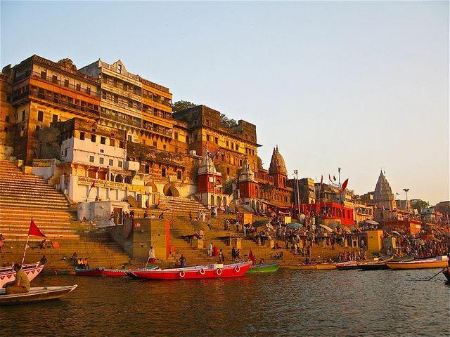
Sandwiched between the rivers Varuna and Ashi as they join the Ganges, Varanasi takes its name from its location. It is also called Kashi, the city of light, but the British, in an endeavor to simplify matters, had coined their own name for the place—Benaras. Varanasi is the city of a thousand temples. The main object of all devotees is the Kasi Vishwanath Temple. According to Hindu belief, Benaras or Varanasi as it is known, is the cosmic center of the Universe. The renowned American novelist Mark Twain once wrote, "Benaras is older than history, older than tradition, older even than legend and looks twice as old as all of them put together."
Altitude: 73.89 sq.km. / 80.71 mts
Climate:(deg C) Summer- Max. 46 Min. 32; Winter- Max. 15.5, Min. 5
Rainfall:11.1 cm. (June to September)
Languages Spoken:Hindi, Bengali, English
Clothing:Summer- Light cottons, Winter- Woollens
Best Season:Throughout the year, but preferably October to March
By Air:
Varanasi is well connected to Bhubaneshwar, Lucknow, Agra & Delhi.
By Rail:
Varanasi is connected by rail with all the major cities.
By Road:
Agra- 610 kms, Allahabad- 127 kms, Bodh Gaya- 240 kms, Gorakhpur- 215 kms, Khajuraho- 406 kms, Kushinagar- 260 kms, Lucknow- 320 kms, Lumbini- 320 kms, Patna- 270 kms Calcutta- 681 kms, Bombay- 1550 kms, Delhi- 710 kms etc.
Rishikesh
Rishikesh, a most tranquil place in northern Uttar Pradesh, surrounded by hills and bisected by the wide and sluggish Ganges, is often claimed as the `Yoga Capital of the World'. It is rightly called the gateway to the Himalayan Shrines of Badrinath, Kedarnath, Gangotri and Yamnotri. Situated 24 km upstream from Haridwar, at the confluence of the Chandrabhaga and Ganga, Rishikesh has long been a spiritual centre. It is said that the sage Raibhya Rishi did severe penance here and as a reward, God appeared to him in the form of Hrishikesh, hence the name.
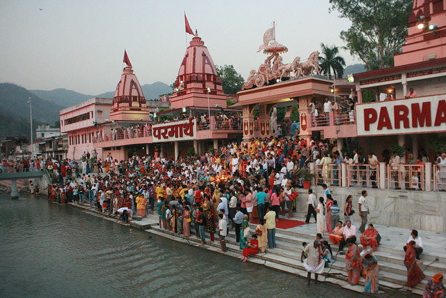
he whole place is considered to be sacred, as it is believed that meditation at this place leads to attainment of salvation. The Riverside is dotted by the ashrams of Sadhus and sages.
Altitude: 11.20 sq.km. / 356 mts.
Climate:(deg C) Summer- Max.44.4, Min.29; Winter- Max.32.2, Min.18.3
Languages Spoken:Garwali, Hindi, Punjabi, English
Clothing:Summer- Cotton & tropical; Winter- Heavy woolen
Best Season:Throughout the year.
By Air:
The nearest airport is Dehradun (Jolly Grant), 35 kms from Haridwar.
By Rail:
Rishikesh is connected by rail via Haridwar 24 kms.
By Road:
Haridwar- 24 kms, Dehradun- 47 kms, Mussourie- 77 kms, Badrinath- 301 kms (Son Prayag), Kedarnath- 228 kms, Gangotri- 258 kms, Yamnotri- 288 kms (Hanuman Chatti), Srinagar-105 kms, Joshimath- 252 kms.
Dehradun
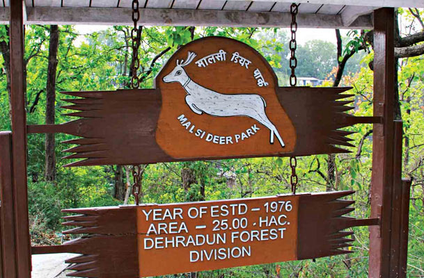
The Doon Valley is situated between the two most important rivers of India i.e Ganga & Yamuna, is most picturesque having moderate climate, nestling a number of places of tourist interest. It is a most picturesque region at the foothills of the panoramic Shivalik ranges.
Altitude: 640 meters
Climate: (deg C)-Summer- Max 36.6, Min 16.7; Winter- Max 23.4, Min 5.2
Languages Spoken:Garhwali, Hindi, English
Clothing:Summer- Cottons, Winter- Woollens
Best Season:Throughout the Year.
By Rail:
Dehradun well connected to major cities.
By Road:
Mussourie- 35 kms, Delhi- 235 kms,
Haridwar- 54 kms, Bombay- 1927 kms, Rishikesh- 42 kms, Agra- 408 kms, Shimla- 280
kms, Yamnotri- 173 kms, Kedarnath- 268 kms and Roorkee- 67 kms etc.
Gangotri
Gangotri is situated in Uttarakhand at the height of 3,048 meters in the magnificent Garhwal Himalayas. The 6 meters high Gangotri shrine is dressed in white granite stone and is situated on the right bank of the river, Bhagirathi. This 18th century temple is dedicated to the Goddess Ganga who is believed to have descended from heaven as the "stream of life" in response to King Bhagirath's penance.
14 kms from Gangotri is Gaumukh, where the source of the holy Ganges- the Gangotri glacier - is situated. Submerged in the water is the "shivling", the rock on which Lord Shiva supposedly sat to receive Ganga. At the legendary source of the river, Goddess Ganga is worshipped in the form of deity. The trek to Gaumukh is gradual, and several pilgrims undertake the journey to pay homage to the river at its known source.
he whole place is considered to be sacred, as it is believed that meditation at this place leads to attainment of salvation. The Riverside is dotted by the ashrams of Sadhus and sages.
Altitude: 3140 meters
Climate:(deg C) Summer- Max.20, Min.5; Winter- Max Subzero, Min.Snowbound
Languages Spoken:Garhwali, Hindi, English
Clothing:Summer- Light woollens, Winter- Heavy woolens
Best Season:May-June and September-October.
Submerged Shivling: A natural Shivling formed of rock, submerged in the river, where according to mythology, Lord Shiva sat when the Ganga first descended to earth. The Shivling is visible only when the water is clear in early winter.
Gaumukh Trek (23 Km): Snout of Gangotri glacier & source of the river Bhagirathi, Gomukh is located at an altitude of 4200 meters.
How To Reach -
By Air:
The Nearest Airport (306 kms) is Jolly Grant.
By Rail:
Nearest Railway head are Dehradun -24 kms and Haridwar.
By Road:
Rishikesh- 24 kms from Haridwar and 43 kms from Dehradun, Delhi- 472kms.
Yamnotri
Yamnotri is the source of the river Yamuna, which is the main tributary of the holy river, Ganges. As the legend goes, Yamnotri was the home of Asit Muni, a famous sage of ancient times. Built in the 19th century, the Yamnotri temple has a black marble idol of Goddess Yamuna. Recently, the temple was destroyed twice by snow and floods but has been reconstructed each time. There are numerous hot water springs near the temple in which pilgrims immerse potatoes and rice tied in pieces of cloth. The meals thus prepared are offered to the deity and then distributed among the pilgrims.
Yamnotri, the source of the river Yamuna, is the westernmost shrine in the Garhwal Himalayas, located on a flank of the Bandarpunch peak. It is said that Maharani Gularia of Jaipur built the temple of Yamnotri in the last decade of the 19th century.
Altitude: 3322 Meters
Climate: (deg. C)-Summer Max 20, Min 6; Winter Max Sub-zero, Min Snow-bound
Languages Spoken:Hindi, Garhwali, English
Clothing:Summer - Light woollens, Winter - Heavy woolens
Best Season:May-June and September-October.
Yamnotri stands in the shadow of Banderpunch Mountain (6315 Meters, Temple of Yamnotri, Surya Kund, hot water spring, Divya Shila. Saptarshi Kund-10 Kms.
How To Reach -
By Air:
Nearest airport is Jolly Grant.
By Rail:
The nearest Railway stations are Dehradun and Haridwar.
By Road:
Yamnotri is easily approached from Rishikesh, Saharanpur and Dehradun.
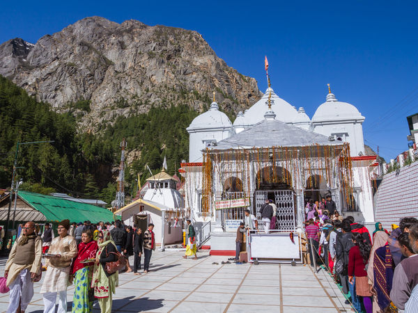
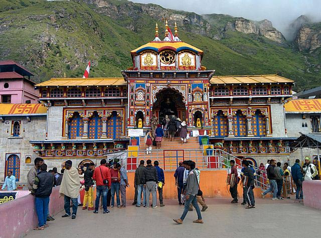
Badrinath
The abode of Lord Vishnu, Badrinath, is situated in the Himalayas (Uttarakhand) at the height of approximately 3,124 meters above sea level. It is on the left bank of the river, Alaknanda. At one time the spot was covered with wild berries ("badris") and was famous as the "Badri Van" (the garden of wild berries)..
Built by the Garwal kings, the Badrinath shrine dates back to more than two centuries. The temple has a black stone idol that depicts Lord Vishnu - the preserver - in a meditative stance with both hands on his lap. Fed by the Badrinath glaciers and the holy Ganges, the sacred river Alaknanda flows by the temple. The temples of Shiva and Vishnu at Kedarnath and Badrinath have been the destination of pilgrims for centuries.
How To Reach -
By Air:
The nearest airport is Dehradun- 335 kms.
By Rail:
Nearest Railhead is Haridwar and Dehradun.
By Road:
Rishikesh- 293 km, Haridwar- 313 km, Kotdwara-325 km, Joshimath- 42 km. Valley of flowers- 38 km. Delhi- 518 km.
Route from Rishikesh to Badrinath
Rishikesh-Deoprayag- 69 kms, Srinagar (U.P)- 105 kms, Rudraprayag- 139 kms, Karnaprayag- 171 kms, Nandaprayag- 92 kms, Chamoli- 202 kms, Pipalkoti- 221 kms, Joshimath- 252 kms and Badrinath- 294 kms.
Route from Rishikesh to Kedarnath via Rudraprayag
Rishikesh-Rudraprayag- 139 kms, Agastamuni- 157 kms, Kund- 171 kms, Guptakashi- 181 kms, Phata- 194 kms, Soneprayag- 207 kms, Gaurikund- 212 kms and Kedarnath- 226 kms, Distance between Gaurikund and Kedarnath- 14 kms has to be covered on foot.
Route from Badrinath to Kedarnath
Badrinath-Joshimath- 42 kms, Chamoli- 92 kms, Gopeshwar- 103 kms, Guptakashi- 183 kms, Gaurikund- 214 kms and Kedarnath- 228 kms.
Route from Rishikesh to Gangotri-Gaumukh
Rishikesh-Narendra Nagar- 16 kms, Tehri- 77 kms, Dharasu- 118 kms, Makuri- 137 kms, Uttarkashi-148 kms, Gangnani- 90 kms, Sukhi- 204 kms, Bhaironghati- 238 kms, Gangotri- 248 kms, Bhojwasa- 18 kms, Gaumukh- 4 kms, Distance between Gangotri & Gaumukh- 22 kms has to be covered on foot.
Route from Rishikesh to Yamnotri (via Dharasu)
Rishikesh-Dharasu-118 kms, Barkot- 178 kms, Sayanchatti - 206 kms, Hanumanchatti- 213 kms, Jankichatti- 221 kms and Yamunotri- 227 kms. Distance between Janakichatti and Yamunotri- 14 kms has to be covered on foot.
Route from Gangotri to Kedarnath (269 kms)
To reach Kedarnath one has to return to Lanka from where there is a road route via Uttarkashi, Tehri, Kiritnagar Srinagar (U.P), Rudraprayag Agastamuni, Kund, Gaurikund.